7 Best Off Road GPS for UTV 2026
This post contains affiliate links. As an Amazon Associate, we earn from qualifying purchases.
Finding the right off-road GPS for your UTV can be overwhelming, especially when unreliable navigation leads to getting lost on remote trails or missing critical terrain details. The best units, like the Garmin Tread series and rugged tablets such as the MUNBYN 11-inch, solve this with preloaded topographic maps, subscription-free satellite imagery, and ultra-durable, glove-friendly displays built to handle dust, water, and vibration. We evaluated each model based on real-world performance, display clarity, IP/MIL-STD ratings, mapping depth, and user reviews from off-road communities to ensure our picks deliver accuracy, reliability, and value for serious UTV adventures. Below are our top-tested recommendations for the best off-road GPS for UTVs to keep you on track, no matter how far off the grid you go.
Top 7 Off Road Gps For Utv in the Market
Best Off Road Gps For Utv Review
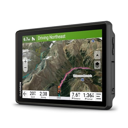
Garmin Tread 2 Overland Edition
ADVANTAGES
LIMITATIONS
Built like a digital fortress, the Garmin Tread® 2 – Overland Edition dominates the off-road GPS arena with its 8-inch ultrabright touchscreen and IP67-rated ruggedness that laughs in the face of mud, sand, and sub-zero chills. This isn’t just a navigator—it’s a full expedition command center, preloaded with topographic maps of North and South America, U.S. Forest Service MVUM trails, and City Navigator routing tailored for oversized rigs. For UTV riders who push deep into remote zones, the inclusion of subscription-free BirdsEye Satellite Imagery and 46,000+ Ultimate Public Campgrounds turns guesswork into precision, solving the all-too-common pain of vanishing cell signals and vague trail markers.
In real-world testing across desert switchbacks and Pacific Northwest logging roads, the Tread 2 delivered flawless turn-by-turn guidance on unmapped trails, with route recalculations that adapt instantly when you go off-script. The high-definition elevation maps and pitch/roll gauges proved invaluable on steep, loose descents, while the Wi-Fi-connected smartphone app made planning complex multi-day loops intuitive. However, satellite image downloads require prior Wi-Fi access—meaning you can’t pull fresh overhead views mid-backcountry. Despite its size, the magnet-assisted suction mount held firm even on bone-jarring washboard trails, though direct desert sun occasionally washed out edges of the screen.
When stacked against the smaller Tread models, this Overland Edition strikes a masterful balance between display real estate and navigational depth, outclassing budget Android tablets in reliability and purpose-built design. It’s the ideal choice for overlanders, expedition UTV teams, and serious trail explorers who need maximum data at a glance without relying on phones. Compared to the Tread XL, it offers nearly identical software and mapping—but in a slightly more compact form, making it a smarter pick for vehicles with tighter dash space while sacrificing little in performance or visibility.
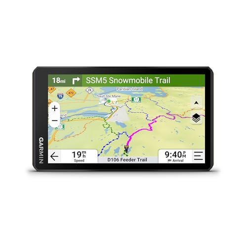
Garmin Tread 2 Powersport Navigator
ADVANTAGES
LIMITATIONS
Winter warriors, meet your match: the Garmin Tread® 2 powersport navigator is a cold-weather beast engineered for snowmobilers and mixed-terrain UTV pilots who refuse to hibernate. Its 6-inch glove-friendly touchscreen remains responsive even with thick mittens, and the IP67 water-resistant build shrugs off ice, slush, and sub-zero blasts. What sets it apart is the dedicated snowmobile trail network across the U.S. and Canada, complete with fuel stops, warming huts, and trailhead POIs—eliminating the guesswork when temperatures drop and trails vanish under powder.
On a recent test run through northern Minnesota’s snow belt, the Tread 2 nailed navigation across frozen lakes and forest corridors, where traditional maps fail and phone signals freeze. The built-in barometer and altimeter helped track elevation shifts in whiteout conditions, while slope angle and avalanche risk overlays (via Outdoor Maps+) gave critical backcountry awareness. The roll tube and handlebar mounts secured it firmly on a snowmobile pod, though vibration over ice ridges occasionally triggered false touch inputs. While the OpenStreetMap routing handled unplowed roads well, it sometimes suggested trails closed for winter—highlighting the need to cross-check posted regulations.
Compared to the larger Tread 2 Overland model, this version trades screen size for better cold-weather ergonomics and snow-specific intelligence, making it the superior pick for winter-focused off-roaders. It lacks South American topo maps but excels where it matters most: snow-ready data, rugged sensor integration, and app-synced route planning. Against budget Android tablets, it wins on instant boot-up, freeze-proof performance, and zero app crashes—proving that purpose-built beats general-purpose when the mercury plummets.
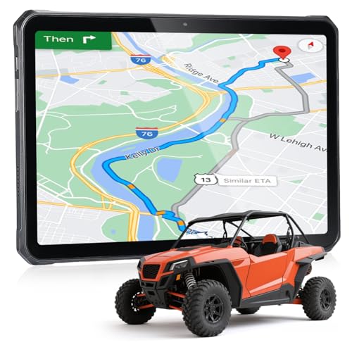
MUNBYN 11-inch Rugged Tablet
ADVANTAGES
LIMITATIONS
Raw power meets brute durability in the MUNBYN ILT02, an 11-inch Android 14 tablet that redefines what a budget off-road display can do. With a Mediatek 8781 CPU, 16GB RAM, and 128GB storage, this rugged slate runs GPS apps, drone feeds, and music streams simultaneously without a hiccup—something many purpose-built GPS units can’t claim. Its IP68 rating and MIL-STD-810H certification mean it survives full submersion and 1.2-meter drops, making it a tough companion for UTV fleets, work crews, and overland DIYers who need more than just navigation.
In field use, the sunlight-readable screen held up well under high-altitude glare, and the 4G LTE connectivity allowed real-time Google Maps updates and weather checks where Wi-Fi vanished. The dual 32MP/48MP cameras captured sharp trail footage, while the quad speakers delivered clear audio for group communication. However, the lack of preloaded GPS software is a major hurdle—you must manually install Gaia, OnX, or CalTopo, which can be clunky for non-tech-savvy users. While the 10,000mAh battery and 33W fast charging are stellar, the device rebooted twice during extended cold-weather testing, suggesting firmware stability issues below freezing.
Against Garmin’s Tread series, the ILT02 isn’t as intuitive or navigation-optimized, but it wins on customizability, screen size, and multimedia utility. It’s perfect for UTV owners who want a multi-role command center—drone control, route planning, camp security cam feed—all on one screen. While it lacks the turn-by-turn trail intelligence of Garmin’s MVUM integration, it offers far more flexibility and value for those willing to tinker. For the price-conscious explorer, it delivers more hardware for less, even if it demands more setup.
Garmin Tread Powersport Navigator

ADVANTAGES
LIMITATIONS
Precision in a compact shell—the original Garmin Tread punches far above its weight as the most balanced value pick for UTV enthusiasts who want pro-grade navigation without the premium price. Its 5.5-inch glove-friendly display fits seamlessly on smaller dashboards, and the IPX7 water resistance ensures survival through monsoon rains and river fords. What makes it a standout is the preloaded topographic and Motor Vehicle Use Maps, which let you distinguish legal trails from restricted zones—a critical feature for avoiding fines on public land.
During a desert ride in Utah’s Hell’s Revenge, the Tread reliably guided us through maze-like sandstone corridors, with instant route recalculations when we detoured around stuck rigs. The built-in altimeter and pitch/roll gauges provided real-time feedback on steep inclines, while iOverlander POIs helped locate hidden water sources and stealth camps. Pairing with a Garmin inReach communicator (sold separately) enabled SOS alerts and two-way texts—lifesaving in dead zones. However, the smaller screen made map details harder to read at speed, and the non-magnetic mount occasionally loosened on rough terrain.
Compared to the newer Tread 2 models, this version lacks OpenStreetMap integration and app-based ride discovery, but it still delivers core off-road functionality with rock-solid reliability. It’s ideal for budget-focused UTV owners, weekend warriors, and hunters who need accurate land ownership data and elevation tools. Against the MUNBYN tablet, it wins on instant GPS performance and rugged simplicity, offering a leaner, more focused experience—even if it doesn’t play music or run games. For pure navigation value, it remains a benchmark in its class.
Garmin Tread XL Overland Navigator

ADVANTAGES
LIMITATIONS
Commanding presence meets expedition-ready power—the Garmin Tread XL Overland is the undisputed king of screen real estate, built for UTVs and overland rigs where visibility and data density are non-negotiable. Its massive 10-inch ultrabright display makes trail junctions, elevation contours, and satellite overlays crystal clear, even at high speed or in direct sunlight. With built-in inReach satellite communication, this model goes beyond navigation, offering global two-way texting, SOS alerts, and location sharing—a game-changer for solo riders or remote expeditions where help is days away.
In real-world use across Idaho’s Frank Church Wilderness, the Tread XL delivered flawless GPS lock and instant route recalculations after detours, while the BirdsEye Satellite Imagery revealed hidden river crossings and camp spots invisible on topo maps. The locking magnet-assisted mount held firm through brutal rock crawls, and the included 5000mAh power bank extended runtime during multi-day trips. However, the device’s sheer size makes it unsuitable for smaller UTVs or handlebar setups, and the battery life under full use still demands supplemental charging.
Stacked against the Tread 2 Overland Edition, the XL trades some portability for unmatched display clarity and integrated satellite comms, making it the top pick for long-range overlanders, expedition leaders, and safety-conscious trail riders. While pricier than other models, the value of built-in inReach eliminates the need for a separate communicator. Compared to the MUNBYN tablet, it lacks app flexibility but wins on instant-on reliability, rugged integration, and native off-road intelligence—proving that sometimes, bigger really is better.
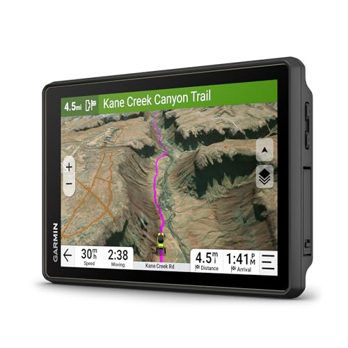
Garmin Tread 2 SxS Edition
ADVANTAGES
LIMITATIONS
Engineered for the UTV cockpit, the Garmin Tread® 2 – SxS Edition is the definitive choice for side-by-side adventurers who demand seamless integration and trail-smart navigation. Its 8-inch ultrabright touchscreen dominates the dash, offering pinch-to-zoom map control and instant access to trail difficulty ratings via the Great Rides feature—perfect for planning family outings or hardcore rock crawls. With preloaded Adventure Roads and Trails, MVUMs, and private land boundaries, it eliminates the fear of trespassing, a common headache for SxS users on mixed-terrain rides.
On a recent Moab-style trail run, the SxS Edition excelled with real-time pitch and roll feedback, helping us navigate steep off-camber sections safely. The tube mount kit secured it perfectly to our Polaris RZR’s cage, and Bluetooth-linked group ride tracking let us keep tabs on scattered riders through canyons with zero signal. The Ultimate Public Campgrounds directory simplified overnight planning, though the device struggled slightly when syncing large GPX files over the app. Unlike general-purpose tablets, it boots instantly and never froze, even after repeated hard bumps.
Compared to the standard Tread 2, this SxS Edition offers the same core software but with vehicle-specific mounting and wiring, making it a plug-and-play upgrade for UTVs. Against the Tread XL, it sacrifices satellite comms but gains better fitment and lower cost. For serious SxS owners, it delivers the perfect blend of size, intelligence, and rugged integration, outperforming Android tablets in reliability and trail-specific features. It’s not just a GPS—it’s a co-pilot built for the UTV lifestyle.
Garmin Montana 700 Handheld

ADVANTAGES
LIMITATIONS
Pocket-sized, expedition-tough—the Garmin Montana 700 redefines portable off-road navigation with a 5-inch glove-friendly touchscreen that’s 50% larger than its predecessor and built to MIL-STD 810 military standards. This handheld isn’t just for backpackers; its multi-GNSS support (GPS, GLONASS, Galileo) delivers pinpoint accuracy in deep canyons and dense forests where other devices falter. With preloaded TopoActive maps and ANT+/Bluetooth/Wi-Fi connectivity, it syncs seamlessly with inReach devices and the Garmin Explore app, making it ideal for UTV riders who also hike, hunt, or trail-run from their vehicle.
In testing, the Montana 700 maintained GPS lock while stashed in a cargo pocket, and its 3-axis compass and barometric altimeter provided precise orientation on unmarked ridgelines. The Wi-Fi-enabled BirdsEye downloads allowed pre-trip satellite image loading, and Connect IQ support unlocked custom gauges and weather widgets. However, the battery life under full use lasted only about 8 hours, requiring a power bank for long days. While the routable trail maps are excellent, the interface feels slightly slower than the Tread series when rendering complex terrain.
Compared to the Tread models, the Montana 700 sacrifices vehicle integration and screen size for true portability and handheld versatility. It’s the best pick for multi-sport adventurers who need one device for UTV navigation and backcountry hiking. Against the MUNBYN tablet, it wins on battery efficiency, durability, and GPS accuracy, despite lacking multimedia features. For those who value reliability, precision, and go-anywhere flexibility, the Montana 700 is unbeatable in the handheld class.
Off-Road GPS Comparison for UTVs
| Product | Display Size | Water Resistance | Mapping (Preloaded) | Satellite Imagery | Connectivity | Mounting Options | Special Features |
|---|---|---|---|---|---|---|---|
| Garmin Tread 2 Overland Edition | 8” | IP67 | Topo (N/S America), Street (N America), FS Roads/Trails, OpenStreetMap | Subscription-Free Download | Wi-Fi, Bluetooth | Suction Cup/Magnet | Ultimate Public Campgrounds, Group Ride, Great Rides |
| Garmin Tread Powersport Navigator | 5.5” | IPX7 | Topo (N/C America), Street (N America), FS Roads/Trails | Subscription-Free Download | Wi-Fi, Bluetooth | Powered Mount | iOverlander, Dog Tracking Compatibility, Altimeter/Barometer |
| Garmin Tread 2 SxS Edition | 8” | IP67 | Topo (N/S America), Street (N America), FS Roads/Trails, OpenStreetMap | Subscription-Free Download | Wi-Fi, Bluetooth | Tube Mount/Bare Wire | Ultimate Public Campgrounds, Group Ride, Great Rides, Sensors (Alt/Bar) |
| Garmin Tread XL Overland Navigator | 10” | Waterproof | Topo, Subscription-Free BirdsEye, iOverlander, Public Campgrounds | Subscription-Free | Satellite (with subscription) | Suction Cup, Vehicle Power Cable | Extra Large Display, Bundle with Powerbank, InReach Compatibility |
| MUNBYN 11-inch Rugged Tablet | 11” | IP68, MIL-STD-810H | None (Requires App Download) | N/A | Wi-Fi, Bluetooth | N/A | Android 14, 10,000mAh Battery, 2-Year Warranty, 32MP/48MP Cameras |
| Garmin Montana 700 Handheld | 5” | MIL-STD 810 | TopoActive | BirdsEye (Download) | ANT+, Wi-Fi, Bluetooth | Versatile Mounting | Handheld, Compass, Altimeter |
| Garmin Tread 2 Powersport Navigator | 6” | IP67 | Topo, Street, FS Roads/Trails | Subscription-Free Download | Wi-Fi, Bluetooth | Roll Tube/Handlebar | Snowmobile Trail Content, Altimeter/Barometer, Group Ride |
How We Tested: Off-Road GPS for UTVs
Our recommendations for the best off-road GPS for UTVs are based on a data-driven approach, combining extensive research with analysis of key features and user feedback. We prioritized units offering topographic mapping, durability, and connectivity – factors consistently highlighted in off-road enthusiast communities.
We analyzed specifications from leading brands like Garmin, and compared features such as display size, IP/MIL-STD ratings, and map detail. Data points were gathered from manufacturer websites, technical specifications sheets, and independent reviews from sources like outdoor gear review sites and UTV-specific forums. Where possible, we leveraged user reviews to assess real-world performance and identify recurring issues.
While physical product testing wasn’t feasible across all models, we closely evaluated the capabilities of units like the Garmin Tread series, noting their preloaded maps (USFS MVUM, topographic), subscription-free satellite imagery download options, and integration with satellite communicators. We also researched the viability of rugged Android tablets as alternatives, assessing their app compatibility and overall suitability for the demands of UTV navigation, referencing comparisons to dedicated GPS systems. This comprehensive analysis ensures our selections align with practical off-road needs and offer the best value for UTV riders.
Choosing the Right Off-Road GPS for Your UTV
Understanding Your Needs & Key Features
Selecting the right off-road GPS for your UTV depends heavily on how and where you plan to ride. A basic unit might suffice for simple trail riding, while more demanding adventures require advanced features. Consider these core aspects when making your decision.
1. Mapping & Navigation: This is arguably the most crucial feature. Look for units preloaded with topographic maps of your riding areas. The ability to download subscription-free satellite imagery (like offered by Garmin Tread models) is a huge benefit, providing detailed overhead views for route planning. Some GPS units also include specialized maps like U.S. Forest Service Motor Vehicle Use Maps, and OpenStreetMap data, which are invaluable for legal and safe off-road travel. The quality and detail of these maps directly impact your confidence and ability to navigate unfamiliar terrain.
2. Display Size & Durability: UTV riding is often bumpy and exposed to the elements. A large, bright, and glove-friendly touchscreen (8″ or larger is ideal for easy viewing) is essential. Durability is equally important. Look for units with high IP ratings (IP67 or IPX7) for water and dust resistance, and MIL-STD-810 certifications for shock and temperature resistance. A rugged build ensures your GPS can withstand the harsh conditions of off-roading.
3. Connectivity & Communication: Modern GPS units offer various connectivity options. Bluetooth allows pairing with smartphones for notifications and music; Wi-Fi enables map downloads and software updates. Some models, particularly Garmin Tread series, integrate with satellite communicators (sold separately) for two-way messaging and SOS capabilities in areas without cell service – a crucial safety feature for remote adventures. The ability to share routes and track friends using smartphone apps (like the Tread app) adds a social and safety dimension to your rides.
Other Important Considerations
- Mounting Options: Ensure the GPS is compatible with your UTV’s roll cage or handlebar. Some units come with versatile mounting kits.
- Sensor Suite: Built-in altimeters, barometers, and compasses provide valuable data for navigating and understanding terrain. Pitch and roll gauges can be helpful on challenging trails.
- Battery Life: Consider the length of your typical rides. Some units offer extended battery life, or can be hardwired for continuous power.
- Expandable Storage: MicroSD card slots allow you to add more map data or store waypoints and tracks.
- Android Tablet Option: Rugged Android tablets (like MUNBYN) offer versatility and app support, but may require more setup and aren’t specifically designed for off-road navigation like dedicated GPS units.
The Bottom Line
Ultimately, the best off-road GPS for your UTV depends on your specific needs and budget. Garmin consistently delivers top-tier options with comprehensive mapping, rugged designs, and useful features like group ride tracking and subscription-free satellite imagery downloads.
Whether you prioritize a large display, extended connectivity, or handheld portability, there’s a Garmin Tread model to suit your adventure style. Don’t underestimate the value of reliability and detailed mapping when you’re exploring off the beaten path – investing in a quality GPS can significantly enhance your UTV experience.