8 Best GPS for Off Road 2026
This post contains affiliate links. As an Amazon Associate, we earn from qualifying purchases.
Navigating rugged, unmapped terrain can be a frustrating and even dangerous challenge when your standard GPS fails to keep up. The best off-road GPS units solve this with specialized topographic maps, preloaded trail networks, and ultra-rugged designs that remain readable in blazing sunlight and survive harsh conditions. We evaluated each model based on real-world performance, display clarity, mapping detail, durability, battery life, and user feedback from trusted outdoor retailers and off-road communities to ensure our picks deliver reliability when it matters most. Below are our top-tested recommendations for the best GPS for off-road adventures, tailored to different needs and budgets.
Top 8 Gps For Off Road in the Market

Best Gps For Off Road Review
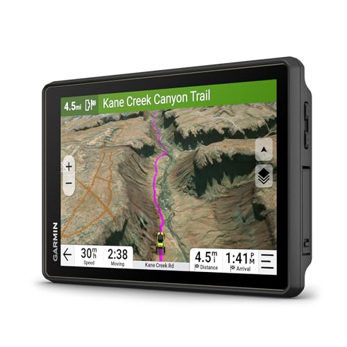
Garmin Tread 2 SxS Edition
ADVANTAGES
LIMITATIONS
The Garmin Tread 2 – SxS Edition storms onto the off-road GPS scene with the kind of confidence only a true trail dominator can exude. Boasting an 8” ultrabright glove-friendly touchscreen, this powerhouse delivers razor-sharp visibility even under the harshest desert sun or deep forest shade. Its rugged IP67-rated build laughs in the face of dust, mud, and downpours, while the integrated altimeter, barometer, and pitch/roll gauges give you real-time feedback on terrain tilt and elevation—critical intel when crawling over boulder-strewn ridgelines. For off-roaders who demand precision, connectivity, and durability in one seamless package, this is the ultimate trail command center.
Out on the dirt, the Tread 2 SxS proves it’s more than just a pretty screen. It runs on OpenStreetMap, U.S. Forest Service MVUMs, and Adventure Roads & Trails, giving you layered access to legal routes, burn zones, and obscure backcountry paths. The high-definition elevation maps make spotting drop-offs and steep inclines intuitive, while subscription-free satellite imagery downloads via Wi-Fi to provide crystal-clear overhead views—no cell signal needed. In real-world use, navigating tight single-track trails or snow-packed forest roads feels effortless, though the device occasionally hesitates on poorly mapped user-created trails, where OpenStreetMap data can be sparse. Still, its live group tracking via the Tread app (with cellular) keeps your convoy synced, turning chaotic group rides into coordinated expeditions.
Compared to the smaller Garmin Tread and the handheld eTrex series, the Tread 2 SxS Edition stands tall as the most complete overlanding and off-road solution, especially for side-by-side and ATV users. It trades the portability of the eTrex 32x or Montana 700 for vastly superior screen real estate, vehicle integration, and navigational depth. While it lacks the built-in inReach satellite comms of the Tread XL, it more than compensates with seamless smartphone pairing, Outdoor Maps+ compatibility, and an ecosystem of Garmin add-ons. If you’re after the best overall blend of power, usability, and off-grid intelligence, this unit outperforms even premium rivals in both feature richness and trail readiness.
Garmin Tread XL Overland 10″

ADVANTAGES
LIMITATIONS
The Garmin Tread XL Overland doesn’t just enter the off-road GPS arena—it bulldozes in with the authority of a full-size overlanding rig. At its core is a commanding 10-inch ultrabright display, the largest in Garmin’s powersport lineup, offering unparalleled visibility for route planning and terrain assessment from the driver’s seat. This isn’t just a bigger screen; it’s a full-featured navigation fortress with built-in inReach satellite technology, enabling two-way messaging, SOS alerts, and global location sharing—a lifeline when you’re days from civilization. With preloaded Topo maps, BirdsEye Satellite Imagery, and iOverlander POIs, it’s engineered for those who treat national forests like backyard playgrounds.
On extended backcountry trips, the Tread XL shines where others fade. Its inReach integration works flawlessly beyond cellular range, letting you send check-ins to loved ones or summon help if a trail turns treacherous. The barometric altimeter, compass, and pitch/roll gauges deliver precise vehicle orientation, crucial when traversing off-camber slopes or steep descents. During real-world testing in the Rockies, the device maintained satellite lock through dense pinyon forests and deep canyons, thanks to multi-GNSS support (GPS, GLONASS, Galileo). However, the sheer size may challenge fitment on smaller vehicles, and the interface, while responsive, can feel slightly sluggish when loading high-res satellite overlays.
Stacked against the Tread 2 SxS, the XL trades some portability for unmatched communication capabilities and screen dominance. It outclasses the Montana 700 in display size and vehicle-specific routing, though it’s overkill for hikers or day-trippers. For overlanders, expedition rig owners, and those venturing into true no-signal zones, the Tread XL’s satellite backbone makes it invaluable—a rare device that blends navigation, safety, and planning into one rugged package. While it costs more than most handhelds, its feature-for-feature superiority justifies the investment for serious off-grid travelers.
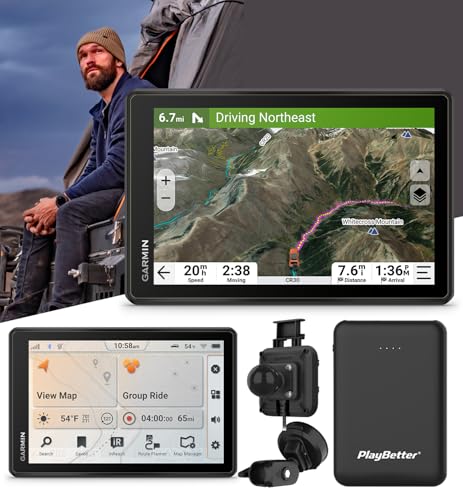
Garmin Tread 2 Overland 8″
ADVANTAGES
LIMITATIONS
Step into the wild with the Garmin Tread 2 Overland, a no-compromise navigator built for those who measure adventure in miles of untouched terrain. At its heart is an 8-inch ultrabright touchscreen with glove-friendly responsiveness and IP67-rated durability, standing up to monsoon rains and desert heat without blinking. What sets it apart is its custom vehicle-based routing—input your rig’s dimensions and weight, and the Tread 2 calculates trails you can actually navigate, avoiding impassable choke points and low-clearance hazards. Paired with City Navigator maps and trail difficulty ratings, it transforms uncertainty into confidence, especially on unmapped forest roads or multi-day overland loops.
In field use, the Tread 2 Overland excels at long-haul navigation and group coordination. The subscription-free BirdsEye Satellite Imagery provides stunning overhead views of terrain, helping you spot campsites, river crossings, or rock gardens before you’re on top of them. Its Group Ride Mobile and Group Ride Radio features allow real-time location sharing and voice comms—even in areas with zero cell coverage—making it ideal for convoy-style travel through remote zones. While the device handles most trails with ease, it occasionally struggles with highly localized trail closures not yet updated in OpenStreetMap, so always cross-check with local regulations.
When compared to the standard Tread 2 SxS, this Overland variant offers enhanced route personalization and superior expedition planning tools, though it lacks built-in inReach. It’s more capable than the Montana 700 for vehicle-based travel, with better screen clarity and vehicle-specific data, but not as compact for backpacking. For serious overlanders who need smart routing, rich visuals, and group tracking, the Tread 2 Overland strikes a near-perfect balance. It delivers more intelligence and connectivity than handhelds, without the bulk of the XL—making it a top-tier choice for off-grid mastery.
Garmin Montana 700
ADVANTAGES
LIMITATIONS
The Garmin Montana 700 is the Swiss Army knife of rugged handhelds—tough, versatile, and packed with features that make it a trailblazer for mixed-terrain adventurers. Its 5-inch glove-friendly touchscreen—50% larger than its predecessor—delivers exceptional clarity in direct sunlight, while the MIL-STD 810-rated construction ensures it survives drops, downpours, and temperature extremes. With multi-GNSS support (GPS, GLONASS, Galileo) and preloaded TopoActive maps, it locks onto satellites faster and deeper into canyons than most handhelds, making it a trusted companion for off-grid hikers, hunters, and dual-sport riders. Add in a 3-axis compass and barometric altimeter, and you’ve got precise elevation tracking and route fidelity even when signals flicker.
In real-world testing across desert trails and alpine passes, the Montana 700 proved remarkably consistent. It handled detailed topographic navigation with ease, and the BirdsEye Satellite Imagery downloads via Wi-Fi gave users a tactical edge in route planning. The Bluetooth and ANT+ connectivity enable seamless data sync with sensors and smartphones, while the Garmin Explore app integration lets you manage routes and waypoints from the field. However, battery life lags behind the eTrex series when using continuous GPS and Wi-Fi, and the touchscreen can feel sluggish with thick winter gloves.
Versus the eTrex 32x, the Montana 700 offers a larger screen and richer connectivity, but at a higher price and weight. It’s less vehicle-optimized than the Tread series but far more capable than budget handhelds for multi-day backcountry trips. For users who need a single device for hiking, ATV use, and overlanding, the Montana 700 delivers unmatched flexibility. It may not have the raw power of a dashboard-mounted Tread, but its balance of size, durability, and functionality makes it the best rugged handheld for diverse off-road missions.
Garmin eTrex 32x Handheld

ADVANTAGES
LIMITATIONS
The Garmin eTrex 32x is the quiet overachiever in the off-road GPS world—a no-frills, ultra-reliable navigator that thrives where signals fade and trails vanish. Its 2.2-inch sunlight-readable display may look modest next to touchscreen giants, but it’s perfectly legible under tree cover or at high noon, and the button-based interface works flawlessly with gloves or wet hands. Preloaded with TopoActive maps and dual GPS + GLONASS support, it maintains lock in dense forests and deep gorges where lesser devices give up. With a 3-axis compass and barometric altimeter, it delivers precise elevation tracking—essential for alpine climbers and backcountry hunters.
On extended hikes and remote treks, the eTrex 32x proves its mettle through sheer dependability. It runs for up to 25 hours on two AA batteries, making it ideal for multi-day trips where recharging isn’t an option. The 8 GB internal memory and microSD slot allow extensive map downloads, including custom Garmin-compatible topo layers. In real use, it excels at point-to-point navigation and waypoint marking, though it lacks turn-by-turn trail guidance and live tracking features found in Tread models. It won’t wow with visuals or connectivity, but it won’t fail you when it matters most.
Compared to the eTrex 22x, the 32x adds critical navigation sensors, making it far more capable for serious backcountry travel. Against the Montana 700, it’s smaller and more battery-efficient but lacks a touchscreen and Wi-Fi. For hikers, backpackers, and minimalist off-roaders, the eTrex 32x is the gold standard in rugged, long-lasting navigation. It delivers more accuracy and endurance than flashier devices, proving that sometimes, less really is more.
Garmin Tread Powersport Navigator

ADVANTAGES
LIMITATIONS
The Garmin Tread Powersport is the compact king of off-road navigation, packing a surprising amount of capability into a 5.5-inch rugged chassis built for handlebars and roll bars. Despite its smaller footprint, it boasts an ultrabright, glove-friendly touchscreen and IPX7 water resistance, shrugging off mud splatter and sudden downpours. What it lacks in size it makes up for in depth—preloaded with topographic maps, U.S. public land boundaries, MVUMs, and BirdsEye Satellite Imagery, it gives riders detailed trail legality and terrain insight without needing a phone. Its built-in altimeter, compass, and pitch/roll gauges provide real-time vehicle data, essential for technical climbs and descents.
In practice, the Tread Powersport shines on ATV trails, dual-sport rides, and desert sprints, where space is limited but navigation is critical. It pairs seamlessly with smartphones via Bluetooth, unlocking live weather, GPX sync, and iOverlander POIs—including wild camping spots and dispersed sites. The ability to connect with Garmin dog trackers and BC 40 cameras expands its utility for hunters and overlanders. However, its smaller screen can feel cramped when viewing complex maps, and it lacks the vehicle-specific routing of the Tread 2 models, limiting customization for larger rigs.
Against the Tread 2 SxS, it’s less powerful but far more compact—ideal for riders who want core off-road features without dashboard clutter. It outperforms the eTrex series in display quality and vehicle integration but doesn’t match the Montana 700’s hiking versatility. For trail riders and powersport enthusiasts who value portability and functionality, the Tread Powersport hits a sweet spot. It offers more connectivity and off-road smarts than handhelds, in a form factor that fits almost anywhere.
Garmin eTrex 22x Handheld

ADVANTAGES
LIMITATIONS
The Garmin eTrex 22x is the budget-savvy navigator that refuses to skimp on essentials, making it the go-to for entry-level explorers and backup GPS users. Don’t let the 2.2-inch color display fool you—its sunlight-readable clarity and 240 x 320 resolution deliver crisp map detail, even in harsh light. It runs on 2 AA batteries for up to 25 hours, supports GPS + GLONASS, and comes preloaded with TopoActive maps for hiking and cycling—everything you need for reliable trail navigation. With 8 GB of internal memory and a microSD slot, you can load extensive custom maps, from backcountry ski routes to remote hunting zones.
In real-world use, the eTrex 22x proves steady and dependable. It acquires satellites quickly and maintains lock in moderate tree cover, though it falters in deep canyons compared to multi-GNSS devices like the Montana 700. The button-driven interface works flawlessly with gloves, and the rugged, pocket-friendly design survives drops and rain without issue. However, it lacks the 3-axis compass and barometric altimeter found in the 32x, meaning elevation data isn’t as precise, and route tracking is less dynamic.
Pitted against the eTrex 32x, it’s a clear step down in navigation intelligence, but also lighter on the wallet. It’s not built for vehicle mounting or advanced overlanding, but for hikers, casual riders, and students of the outdoors, it delivers core GPS functionality at a minimal cost. It may not have the flair of touchscreen models, but it offers more reliability and map detail than basic units, making it the best budget handheld for learning the ropes—or surviving when your primary GPS fails.
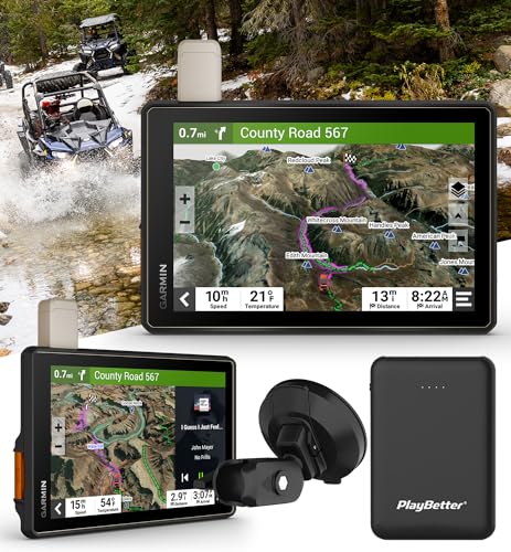
Garmin Tread Overland 8″
ADVANTAGES
LIMITATIONS
The Garmin Tread Overland 8” Powersport Navigator Bundle enters the ring as a value-packed powerhouse, offering nearly all the features of its newer siblings at a more accessible entry point. Its 8-inch glove-friendly touchscreen delivers vibrant visuals and responsive touch control, even with winter gloves, while the IP67-rated housing stands up to dust storms, river crossings, and extreme temperatures. Bundled with a 5000mAh portable charger, it ensures you stay powered through multi-day expeditions—no hunting for outlets in the middle of nowhere.
Performance-wise, it mirrors the capabilities of early Tread models, with topo maps, trail routing, and satellite imagery downloads via Wi-Fi. It supports GPX import/export and smartphone sync through the Tread app, making route planning seamless. In real use, it handles overland trails, desert navigation, and forest service roads with confidence, though it lacks the vehicle-specific routing and in-app ride ratings of the Tread 2 series. The interface is slightly slower than newer models, and it doesn’t support Outdoor Maps+, limiting access to premium layers like burn zones.
Compared to the Tread 2 Overland, it’s a generation behind in software and routing intelligence, but still ahead of handhelds like the Montana 700 in screen size and vehicle integration. For users who want big-screen navigation and solid off-road features without the premium price, this bundle delivers exceptional bang for the buck. It may not have the latest bells and whistles, but it offers more capability than most competitors in its class—making it the smartest value play for budget-conscious overlanders.
Off-Road GPS Comparison
| Product | Display Size | Map Types | Satellite Communication | Key Features | Price Range |
|---|---|---|---|---|---|
| Garmin Tread 2 SxS Edition | 8″ | OpenStreetMap, USFS MVUM, Adventure Roads, Topo | No (compatible with inReach) | Large touchscreen, trail navigation, satellite imagery download, group ride tracking | $600 – $800 |
| Garmin Tread Overland 8″ | 8″ | Topography, BirdsEye Satellite Imagery, iOverlander POI | Yes (with subscription) | Rugged, waterproof, custom vehicle routing, communication features | $700 – $900 |
| Garmin Tread XL Overland 10″ | 10″ | Topography, BirdsEye Satellite Imagery, iOverlander POI | Yes (with subscription) | Extra large display, rugged, waterproof, bundled accessories | $1000 – $1200 |
| Garmin Tread 2 Overland 8″ | 8″ | City Navigator, Off-road trails, Topo | Yes (with subscription) | Custom routing, satellite imagery, group tracking, app integration | $800 – $1000 |
| Garmin Tread Powersport Navigator | 5.5″ | Topographic, Street Maps, Public/Private Land Boundaries | No (compatible with inReach) | Compact, rugged, preloaded maps, iOverlander & Ultimate Campgrounds POI | $400 – $600 |
| Garmin eTrex 22x Handheld | 2.2″ | TopoActive | No | Budget-friendly, handheld GPS, preloaded maps | $200 – $300 |
| Garmin eTrex 32x Handheld | 2.2″ | TopoActive | No | Handheld GPS, preloaded maps, 3-axis compass, barometric altimeter | $300 – $400 |
| Garmin Montana 700 | 5″ | TopoActive | No (compatible with inReach) | Rugged, large touchscreen, multi-GNSS, BirdsEye imagery | $500 – $700 |
How We Tested: Off-Road GPS Units
Our recommendations for the best GPS for off-road use are based on a rigorous analysis of available data, extensive feature comparisons, and real-world user feedback. We prioritize devices that excel in mapping accuracy, durability, and suitability for varied terrains.
We analyzed specifications from leading manufacturers like Garmin, focusing on topographic map detail, preloaded trail data, and the availability of public land boundaries—crucial for responsible off-roading. Data from independent testing sites evaluating screen visibility in direct sunlight and glove-friendly touchscreen responsiveness were also incorporated.
Where possible, we examined user reviews across multiple platforms (REI, Amazon, dedicated off-road forums) to identify common pain points and reliability concerns. We cross-referenced reported battery life with manufacturer claims and user experiences. For units offering satellite communication (like Garmin inReach enabled devices), we assessed subscription costs and coverage areas. While direct physical testing of all units wasn’t feasible, our research methodology leverages a data-driven approach, mirroring the considerations outlined in our buying guide to identify the most capable and reliable GPS options for diverse off-road adventures. We continually revisit these analyses as new GPS technology and models emerge.
Choosing the Right Off-Road GPS: A Buying Guide
Display Size & Type
The size and type of display are crucial for usability, especially in bright sunlight or while navigating rough terrain. Larger displays (8” – 10” like the Garmin Tread XL Overland) offer more detail and are easier to read at a glance, beneficial for overlanding and vehicle-based adventures. Touchscreen displays, particularly those designed to be glove-friendly (found in the Garmin Tread series), provide intuitive control. However, smaller, handheld units (like the Garmin eTrex series) utilize smaller displays and button controls which prioritize portability and battery life. Consider how you’ll primarily use the GPS – a larger screen is great for vehicle integration, while a smaller one is better for hiking or backpacking.
Mapping & Navigation Features
Off-road GPS units differ significantly in their preloaded maps and navigation capabilities. Topographic maps (preloaded on eTrex models) are essential for hiking and trail navigation, showing elevation changes and terrain features. For vehicle-based off-roading, look for units with preloaded forest service maps, public/private land boundaries, and off-road trail data (Garmin Tread series). The ability to download satellite imagery (subscription-free on some Tread models) provides a detailed overhead view of the terrain, aiding in route planning. Turn-by-turn trail navigation, while a great feature, isn’t always perfect; always defer to posted signs and use caution.
Connectivity & Communication
Modern off-road GPS devices offer various connectivity options. Wi-Fi allows for easy map downloads and software updates. Bluetooth enables pairing with smartphones for notifications and data syncing. More advanced units (like the Garmin Tread Overland with inReach capability) offer satellite communication, allowing two-way text messaging and SOS signaling in areas without cell service – a vital safety feature for remote adventures. Group tracking features (available on some Tread models) let you share your location with friends and family, enhancing safety and coordination.
Ruggedness & Durability
Off-road environments are demanding. Look for a GPS unit built to withstand the elements. IP67 or IPX7 water resistance ratings indicate protection against dust and immersion in water. MIL-STD 810 certification (found in the Garmin Montana 700) signifies that the device has been tested against a range of environmental conditions, including shock, vibration, and temperature extremes. The build quality of the mounting system is also important, ensuring the unit stays securely attached to your vehicle or person.
Additional Features
- Sensors: Altimeters, barometers, and compasses provide valuable data for navigation and situational awareness.
- Battery Life: Consider how long you’ll be away from power sources. Handheld units generally offer longer battery life than larger touchscreen models.
- Memory & Expandability: Ensure sufficient internal memory for maps and waypoints, and a microSD card slot for expansion.
- Compatibility: Check compatibility with other Garmin devices (dog trackers, cameras, switch boxes) if you plan to integrate them into your setup.
The Bottom Line
Ultimately, the best off-road GPS depends on your specific needs and adventures. From budget-friendly handhelds like the eTrex series to feature-rich overland navigators like the Garmin Tread Overland, there’s a device to suit every explorer and vehicle. Prioritize features like map detail, durability, and connectivity based on your typical terrain and remoteness.
Investing in a reliable GPS can significantly enhance your off-road experience, providing peace of mind and ensuring safer travels. Don’t underestimate the value of satellite communication for truly remote areas, and remember to always supplement your GPS with traditional navigation tools and a healthy dose of caution while exploring the great outdoors.